Surfzone Costa Rica
  • Major Beaches by Zone
    • Map of Major Breaks
    • North Guanacaste >
      • Ollie's Point
      • Witch's Rock
      • Playa Grande
      • Tamarindo
      • Playa Langosta
      • Avellanas
      • Playa Negra
      • Junquillal
    • Nicoya Peninsula >
      • Nosara/Playa Guiones
      • Playa Camaronal
      • Playa Marbella
      • Playa Ostional
      • Mal Pais
      • Playa Pelada
      • Santa Teresa
      • Playa Carmen
    • Central Pacific >
      • Boca Barranca
      • Playa Escondida
      • Jaco
      • Roca Loca
      • Playa Hermosa
      • Esterillos
      • Playa Bejuco
      • Bocas Damas
      • Quepos
    • South Central Pacific >
      • Matapalo
      • Dominical
      • Punta Dominical
      • Dominicalito
      • Punta Achiote >
        • Playa Bonita
      • Playa Hermosa
    • South Pacific >
      • Drake Bay
      • Cabo Matapalo
      • Pan Dulce
      • Playa Zancudo
      • Backwash
      • Punta Burica
      • Pavones
    • Caribbean >
      • Isla Uvita
      • Black Beach, Cahuita
      • Surfing Stuff >
        • A History of Surfing >
          • Cool Surf Videos
      • Puerto Viejo/Salsa Brava
      • Playa Cocles
      • Manzanillo
  • Hotels and Restaurants
    • Tamarindo Hotels/Rest
    • Nosara Hotels & Restaurants
    • Mal Pais Area Hotels & Restaurants
    • Jaco Beach Area Hotels & Restaurants
    • Quepos/Manuel Antonio Hotels & Restaurants
    • Dominical/Uvita Area Hotels & Restaurants
    • Osa Hotels >
      • Osa Peninsula Restaurants
    • Pavones Hotels & Restaurants
    • Caribbean Zone Hotels/Restaurants >
      • Cahuita Hotels & Restaurants
      • Puerto Viejo Hotels & Restaurants
  • Costa Rica Info
    • About Costa Rica
    • Costa Rica Map
    • Festivals of Costa Rica
    • Costa Rica National Parks >
      • Arenal National Park
      • Barbilla National Park
      • Barra Honda National Park
      • Braulio Carrillo National Park
      • Cahuita National Park
      • Carara National Park
      • Chirripo National Park
      • Cocos Island National Park
      • Corcovado National Park
      • Diria National Park
      • Guanacaste National Park
      • Irazu Volcano National Park
      • Juan Castro Blanco National Park
      • La Amistad International Park
      • La Cangreja National Park
      • Las Baulas National Marine Park
      • Manuel Antonio National Park
      • Maquenque National Park
      • Palo Verde National Park
      • Piedras Blanco National Park
      • Poas Volcano National Park
      • Rincon de la Vieja Volcano National Park
      • Santa Rosa National Park
      • Tapanti National Park
      • Tenorio National Park
      • Tortuguero National Park
      • Turrialba
    • Typical Questions
    • International Air Service
    • Costa Rica Domestic Air Travel >
      • Nature Air
      • Sanza
    • Driving in Costa Rica >
      • Car Rentals
    • U.S. Embassy Notices
  • Costa Rica Properties
    • Mi Tierra
    • Hotel Escazu
  • Community Service
    • Environmental Awareness
  • Costa Rica Golf
  • Monteverde Tours
  • Costa Rica News
  • New Page

                                                                           Avellanas

Guanacaste Zone
Tamarindo Area Hotels/Rest
Major Breaks by Zone
Nosara Hotels & Restaurants
Home/Contents
Hotels & Restaurants by Zone

                     Scroll Down for
          Magic Seaweed Surf Report

Wave Type - Beachbreak w/peaks
Bottom - Uneven reef and sand
Swell Window - Southwest to Northwest
Tide - Mid to High
Wind - East

              Avellanas/Little Hawaii

Picture
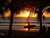
A beautiful Avellanas Sunset
Avellanas is another of the satellite beaches of Tamarindo. It is about 10 km south and about a 25 min. ride. avellanas is made up of a series, about 5,  of rock reefbreaks and a rivermouth on a 2 mile stretch of beach. The reefs produce semi-hollow rights and left that can be very fun. Because it picks up more swell than Tamarindo, crowds get spread out among the different breaks and one can often find an uncrowded peak. As is true for all the Tamarindo spots, Avellanas breaks best on a mid tide with a south/southwest swell and an east wind. It is a sand and  rock bottom with exposed rock at low tide. It is at is biggest during the summer, May through October or November. To get there, drive south about 10 km and look for signs for Cabinas Las Olas. Follow the signs.     

For Avellanas surf info go to:
http://magicseaweed.com/Avellana-Surf-Report/920/

                     Marker - Playa Langosta
 Latitude  10.2914009  Longitude10.2914009  


crsurfzone.com