Cocos Island

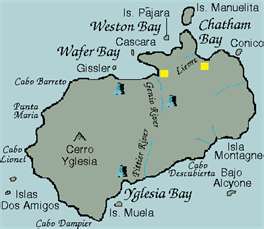
Cocos Island (Spanish: Isla del Coco) is an uninhabited island (except for the permanent ranger station) located off the shore of Costa Rica (to be distinguished from Cocos Island, Isla de Cocos, Panama in the Pearl Islands). It constitutes the 11th district (one of 13) of Puntarenas Canton of the province of Puntarenas It is one of the National Parks of Costa Rica. It is located in the Pacific Ocean, approximately 550 km (340 mi) from the Pacific shore of Costa Rica, at 05°31′08″N 087°04′18″W. With an area of approximately 23.85 km² (9.2 mi²), about 8×3 km (5×1.9 mi) and a perimeter of around 23.3 km, this island is more or less rectangular in shape.Surrounded by deep waters with counter-currents, Cocos Island is admired by scuba divers for its populations of Hammerhead sharks, rays, dolphins and other large marine species. The extremely wet climate and oceanic character give Cocos an ecological character that is not shared with either the Galapagos Archipelago or any of the other islands (e.g., Malpelo or Coiba) in this region of the world.
Back to National Parks Back to Home/Contents |
Marker - Cocos Island National Park
|
-
Major Beaches by Zone
-
Hotels and Restaurants
-
Costa Rica Info
- About Costa Rica
- Costa Rica Map
- Festivals of Costa Rica
-
Costa Rica National Parks
>
- Arenal National Park
- Barbilla National Park
- Barra Honda National Park
- Braulio Carrillo National Park
- Cahuita National Park
- Carara National Park
- Chirripo National Park
- Cocos Island National Park
- Corcovado National Park
- Diria National Park
- Guanacaste National Park
- Irazu Volcano National Park
- Juan Castro Blanco National Park
- La Amistad International Park
- La Cangreja National Park
- Las Baulas National Marine Park
- Manuel Antonio National Park
- Maquenque National Park
- Palo Verde National Park
- Piedras Blanco National Park
- Poas Volcano National Park
- Rincon de la Vieja Volcano National Park
- Santa Rosa National Park
- Tapanti National Park
- Tenorio National Park
- Tortuguero National Park
- Turrialba
- Typical Questions
- International Air Service
- Costa Rica Domestic Air Travel >
- Driving in Costa Rica >
- U.S. Embassy Notices
- Costa Rica Properties
- Community Service
- Costa Rica Golf
- Monteverde Tours
- Costa Rica News
- New Page
